


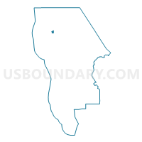
Voting District 30471, San Mateo County, California
About
Outline

Summary
| Unique Area Identifier | 542871 |
| Name | Voting District 30471 |
| County | San Mateo County |
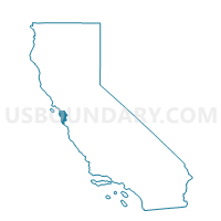
| State | California |
| Area (square miles) | 0.37 |
| Land Area (square miles) | 0.37 |
| Water Area (square miles) | 0.00 |
| % of Land Area | 100.00 |
| % of Water Area | 0.00 |
| Latitude of the Internal Point | 37.58352610 |
| Longtitude of the Internal Point | -122.45483170 |
Maps

Graphs
Select a template below for downloading or customizing gragh for Voting District 30471, San Mateo County, California


Neighbors
Neighoring Voting District (by Name) Neighboring Voting District on the Map
- Voting District 30225, San Mateo County, CA
- Voting District 30310, San Mateo County, CA
- Voting District 30465, San Mateo County, CA
- Voting District 30470, San Mateo County, CA
Top 10 Neighboring County Subdivision (by Population) Neighboring County Subdivision on the Map
- South San Francisco CCD, San Mateo County, CA (306,115)
- Half Moon Bay CCD, San Mateo County, CA (28,894)
Top 10 Neighboring Place (by Population) Neighboring Place on the Map
Top 10 Neighboring Elementary School District (by Population) Neighboring Elementary School District on the Map
- Laguna Salada Union Elementary School District, CA (36,664)
- Millbrae Elementary School District, CA (24,424)
Top 10 Neighboring Secondary School District (by Population) Neighboring Secondary School District on the Map
- San Mateo Union High School District, CA (225,423)
- Jefferson Union High School District, CA (142,700)